Wednesday, 20 July 2016

The last leg: Rotherhithe to the Thames Barrier


We had decided, some time ago, that our objective was the Thames Barrier, i.e. the most obvious point to differentiate river and sea, and the end of the original Thames Path National Trail, not its more recent short extension. So this was our last leg, and we were accompanied by family members to mark the occasion. As this walk wound around the Isle of Dogs (but on the south bank), the new buildings of Canary Wharf seemed to be constantly with us.
The walk from Rotherhithe continued mostly along the shoreline, past former dock and industrial areas now mostly used for housing, and with the river now opening out. Nelson House (pictured) is on one of the short stretches where the path has to duck inland round a block of buildings. Our first stop was at the Surrey Docks Farm, with its artfully designed steel gates. This is indeed, as the guidebook says, "delightful", and was busy with children and families when we called in for refreshment and a toilet break.  
As we first saw Greenwich in the distance, what appeared to be blocks of flats turned out, on closer inspection, to be a cruise ship. This became clearer as we approached and made it out, eventually,as 'The World'. Approaching Greenwich itself, the path regrettably wanders away from the riverside through Pepys Park and then some backstreets. A new footbridge across Deptford Creek, not in our guidebook, takes the path back towards the frontage as we approached the Cutty Sark and tourist hotspot of Greenwich. The tide was very high as we walked around the front of the Royal Naval College, waves splashing onto the narrow path.

We stopped for Sunday lunch at the Trafalgar Tavern.  Food was good enough but surroundings a little pretentious. After this, signage on the Thames Path became a little confusing, the prospect of a short cut across the North Greenwich peninsula making our destination appear closer than it was for taking the long way round. We continued past some still-open industrial wharves, then a massive golf range, towards the Dome. The Greenwich Peninsula Ecology Park is a nice little spot right on the path (and, for us, another toilet break).

Soon, we began to approach our destination. Looking back, we could see the towers of London and the Emirates cable car link that we had earlier passed under.  

And then, finally, the Thames Barrier:


Here, the end of the Thames Path is formally marked, and the length of the Path represented in a mural in concrete. We didn't call at the barrier visitor centre.

A little forward planning meant I had bought a bottle of champagne at Champagne & Fromage in Greenwich (such opportunities to purchase not obviously available at the barrier). We celebrated our completion of the Thames Path.

Tuesday, 7 June 2016

Vauxhall to Rotherhithe

Now entering the congestion charge zone, we were in central London proper. 

Straightaway, we were treated to the SIS building at Vauxhall Cross.  This is a grand piece of architecture viewed from far away, but, seen  close up, the modern interpretation of art deco style is even more impressive.

Having started late in the day, and with a daughter (later two) for company, we stopped at the Tamesis Dock floating pub for refreshment, then continued. After passing Westminster Bridge, we had to remind ourselves we were still on the Thames Path. On a summer Saturday afternoon this was choc-a-bloc with tourists,  with even a one-way system for walkers at one point. Needless to say, the Thames Path was not the object of their tours.

Throngs of people continued all the way along to Tower Bridge. At Blackfriars we discovered there is one railway station even closer to the Thames Path than Barnes Bridge.

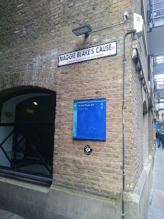
After Tower Bridge, once again we were in the milieu of new developments, but in this eastern area a little more respectful of the local style.  Maggie Blake's Cause commemorates a local resident who fought successfully to continue riverside access to the public as these developments were built. Now the Thames Path follows this alley named after her.

Towards Rotherhithe, the new developments give way to more ordinary housing and once again we were among locals who actually live by the river. We stopped at the Angel, a pub we have visited once before, and were glad to be back. It has a sign saying the windows should be closed when the tide is in.

We have passed through central London: the river here is almost the sea. We are nearly finished.


Barnes Bridge to Vauxhall

Friday was not much warmer than Thursday in London, just a little calmer. We were still on the boat-race stretch, with evidence all the way to Putney as crews in training passed us on the river in each direction. There was also a lot of boating coming and going on the land. We passed Boat Race landmarks: the Leg o'Mutton (which we couldn't see for the trees), Hammersmith Bridge and the Harrods Furniture Repository.

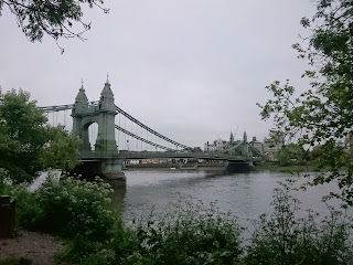
Hammersmith Bridge (pictured) is probably the blingiest of the Victorian bridges. We liked it.

Beverley Brook (also familiar to us as a character in the Peter Grant series) joined us just before Putney.

After passing Putney, the path changed completely: it was now truly urban. Since arriving in Greater London, the path underfoot had generally been metalled with some sort of chippings. But once we passed Putney, we were always walking on a hard surface: tarmac, concrete or paving. Where we encountered green areas - as in Wandsworth Park - this was formal planting, not the sort of semi-wild random growth were had seen along the riverside from Teddington. 

What the guidebook describes as "one of the path's less attractive diversions" at the mouth of the Wandle, reminded us, as we passed a recycling centre and sundry industry, that we were now in the middle of the metropolis.

Passing along the Wandsworth and Battersea banks, there were cranes eeverywhere and swanky new flats going up. We were, however, struck by by how quiet this area was in terms of human activity: whereas earlier in the day we had been accompanied by joggers, baby-walkers and dog-walkers, along here it seemed very few people actually live here. This is a sorry story.
Lunch was taken at the Prince Albert a good break after having completed most of our walk for the day, followed by an ice-cream from La Gondola al Parco in Battersea Park (a proper Italian place in an Art Deco building).

As we approached Vauxhall, the river continued to widen and we began to see landmarks of central London ahead.


Teddington to Barnes Bridge

From Teddington, the path splits, with one on each bank. We thought initially to do the shorter of the two on each leg, and then realised that this would take us on the South Bank every time. Why, when the river curves both ways? Because the north bank is (generally) more developed, which means more diversions around riparian properties. This means the south bank is more of a riverside walk, and so confirmed our choice as the better option.

Twists and turns in the river mean that at Teddington (and a few other places), the south bank is, in fact, north of the river, but we knew what we were doing.

An old friend with considerable local knowledge met us at Teddington station (pictured) on Thursday. It was unseasonably cold in London for June - possibly the coldest day we've had on the whole walk.

The stroll along to Richmond was pleasant enough, along a wooded former towpath. Just before Richmond, our local guide took us just off the Thames Path, along River Lane, the cafe at Petersham Nurseries. We would never have found this ourselves, and it's not in the giuidebook, but a lovely stop-off with home-made cake to have with our teas and coffees. We firmly commend this place to Thames Path walkers.

A breezy walk around Richmond Deer Park was surprisingly green on both sides of the river, considering how close we were to central London. Later, the Brent river and the Grand Union Canal joined on the opposite bank. At Kew we stopped at the Greyhound, apparently a pub from the outside, but more like a restaurant inside, so much so that ordering drinks at the bar wasn't welcomed.

It wasn't far after that to Mortlake - beginning the Boat Race part of the walk - then Barnes Bridge. As we had company and still needed to catch up on old times, another tea break was called for  - this time at Orange Pekoe. We left from Barnes Bridge station, remarking that this was the closest station to the Thames Path that we had seen anywhere from the source.

Friday, 8 April 2016

Shepperton to Teddington


Starting now from Shepperton station and continuing along the 'alternative route', we crossed the river at the modern Walton Bridge to rejoin the towpath. This was a very pleasant Sunday morning with a number of dog-walkers, joggers and cyclists around us.


The towpath continues on the south bank towards Sunbury, more built-up now on the far side, but later giving way to waterworks. Our side had busy playing fields, disused reservoirs, a few houses, then giving way to Hurst Park as we passed Sunbury-on-Thames.

There is now more by way of architecture than nature to see and photograph. The picture of Hampton church across the river benefits from the trees not yet being in leaf.
We stopped for lunch at the The Prince of Wales just before crossing the bridge towards Hampton Court Palace. It being Sunday lunchtime, there were lots of people out eating (although, to be fair, many were still having breakfast, which made us feel a little superior) and the Prince of Wales is in a busy street of busy eating places. Although it was clear people had booked, they still were able to accommodate us and we had an good meal to revive us.


This is an important milestone on the route, because here the guidebooks change. We had finished Thames Path in the Country (a replacement copy for the one that had fallen in the Thames at Henley), and now Thames Path in London came out of the rucksack. The change of guide books means a change of map scale and style - we found after a bit that we were no longer keeping an eye out for streams, fields and footpaths of the 1:50,000 mapping, but now navigating more by street names. Because by now we are in more of an urban landscape, the new guide book sees less need to tell us where we may find refreshment stops.

We have visited Hampton Court Palace a few times before, so we walked past this time continuing towards Kingston. Just after crossing at Kinsgton bridge, the guide alerts us to look at the footings of the 12th century bridge and a 14th century cellar, both in the John Lewis basemeent. The cellar is more impressive, the other looking like any old wall.

 
And then on to Teddington, which is another milestone, the last lock; from now on the river is tidal. (It's curious that the guide books don't hand over here rather than at Hampton Court)  Its station is also within Oyster card territory, so now we won't need to buy a train ticket for each journey. From here onwards, there will be a path on both banks of the river, but our objective when we start again is to cover the river once, not both sides.

Staines to Shepperton

We resumed the walk last weekend. This first day was shorter because we only had a half day, having arrived in London that morning, so it was early afternoon by the time we got to Staines. We found the river a little fuller than on our more usual summertime walks.


The path from Staines mostly follows riverside properties - of all shapes and sizes - so was never truly rural. An information board at Dumsey Meadow, just below Chertsey Bridge, claims that it is the only unimproved meadow land on the Thames in Surrey, not exactly a huge record, but it was a small patch of nature with some distance from roads and buildings.   Here and elsewhere, branches that had just started budding had been blown down from trees and strewn along the ground - the very recent effects of storm Katie.


Wildlife here seems very used to human contact, allowing us to approach closer. 


Approaching Shepperton, the old towpath crossed the river at a point where we are supposed to take the ferry to the Weybridge side, one of few remaining operating ferries on the Thames. Because we were aiming to return via Shepperton station, our route took us on the alternative route of the path on the north bank. 

Monday, 13 July 2015

Henley to Staines: four days reviewed

The main difference with this leg of the walk was that we had decided to stay overnight in one place: in this case the Premier Inn at Slough. The advantage of this was no longer needing to carry everything with us, and also a little extra flexibility as to how far to walk each day. We did in fact use that flexibility, varying our itinerary slightly from the original plan. That all worked, but while the Premier Inn was good for our purposes, we wished we had chosen a hotel closer to the station, as we quickly got bored with the walk between one and another, done twice a day. Slough also is not a wonderful place to dine out.

This was all possible of course because we are getting closer to London and the rail network connects up our stops. As we approach London, and Heathrow Airport, the aircraft get more frequent, closer and noisier. Not surprisingly, the walk itself has become less rural. Although there still are plenty of stretches where we were walking through open fields, away from traffic noise, we didn't really spot any of the more interesting wildlife  - that is, beyond the usual geese, ducks and swans - that we had seen higher up the river.

Best lunch stop was the Flower Pot, a place with real character, and the best evening meal was one we had at some friends' house on Friday evening.